
Six labels, several different experiences.
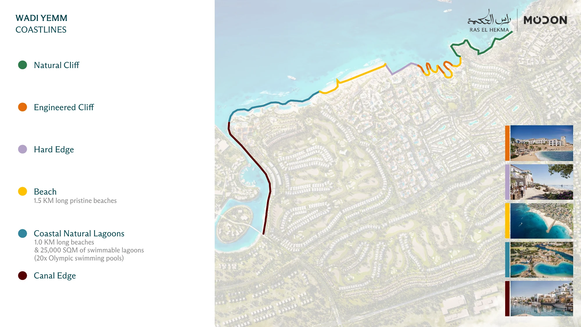
Page 24 of the June toolkit distinguishes coastal natural lagoons, beach, hard edge, engineered cliff, natural cliff and canal edge. These are categories in the proposed shoreline design. They are not a present swimming-safety classification, and the guide does not assign an exact home to a category without its plan.
| Plan label | What the distinction helps you notice | Ask about the actual property |
|---|---|---|
| Beach | The plan describes a beach edge; it is different from a cliff or engineered boundary. | Is there continuous resident access, what route reaches the sand, and who manages it? |
| Coastal natural lagoons | The toolkit’s lagoon terminology describes a water setting distinct from the open coast. | How is that specific water body managed, monitored and made accessible? |
| Hard edge | A constructed water boundary can support a waterfront experience without a sandy beach directly below. | Is access via a quay, promenade, steps or a separate beach? |
| Engineered cliff | The proposed edge is deliberately engineered; visual height and access can differ from a flat beach. | Request levels, edge treatment and the exact descent/access arrangement. |
| Natural cliff | A natural cliff setting involves a different ground-level relationship to the sea. | Check terrain, setbacks and legal/safe access rather than estimating from the view. |
| Canal edge | The waterfront belongs to a canal setting, not automatically direct Mediterranean frontage. | Clarify the permitted uses, resident access and management responsibilities. |
Coastline length is not swimmable beach length.
The toolkit describes Wadi Yemm’s whole coastline as 4.5 km and its swimmable beaches as 2.5 km. Page 24 breaks the beach descriptions into a 1.5 km pristine-beach section and a 1.0 km beach/lagoon-related section. The difference in those headline measures is useful: not every metre of coastline is described as swimmable beach.
02 / READ THE WATER
One waterfront.
Six different edges.
Choose a type of shoreline to see it clearly. Use “Close up” to inspect its shape on the same plan. A sea view does not always mean a beach below the home.
Guide lines follow the water’s edge in this June plan. The shoreline types come from Modon’s published key. The points where one type changes to another are approximate. © Modon · planned design.
Beach
1.5 km beach length in the toolkitA sandy coast. Ask how you reach the beach and who is allowed to use it.
Different measures, not three lengths to add. These are planned descriptions, not present access or safety checks.
Proportional length comparison; not a geographic ordering or verified current-access diagram. Developer figures, June toolkit p24–25.
The source’s 25,000 m² natural-lagoon figure and 12,000 m² lagoon/beach description in the Wadi East/West section refer to different parts of the material. The guide does not add them together as a verified 37,000 m² total or assume they have identical scope.
A water view is only one of the questions.
For a real home, separate the view from the route and the rights. A photograph or rendering can show water from a balcony without establishing what is directly in front of the building, how far the usable shore is on foot, or whether your guests can enter it.
- Locate the exact building and floor. Use the current collection plan and an identified unit, not a generic project pin.
- Read the foreground. Identify the water type, terrain, road, promenade, planting and any planned buildings between the home and water.
- Trace the permitted route. Check gates, crossings, steps, slopes and any seasonal closures. Straight-line distance is not that route.
- Confirm the entitlement. Owner, tenant and guest access can differ, and a hotel or club can have its own charges.
- Confirm conditions for your dates. A planned swimmable lagoon is not an operating facility or a guarantee of safe sea conditions on a particular day.
Sources for this reading.
Supplied publications are identified by document title and page in the source register. No private chat export or sales inventory is published. Developer material describes the intentions and specifications of its edition; the guide’s analysis and questions are original.
Modon · Wadi Yemm extended sales toolkit — June 2026 ↗Modon · Waterfront Residences Wadi Yemm — factsheet ↗Miran Hills; plan branded OBMI · Hacienda Ras El Hekma — original plan imagery ↗Suggest a correction ↗