ANNOUNCED PRECINCT
Wadi Yemm
Modon’s opening precinct. A contractor also identifies an awarded construction package; this does not establish completion across the precinct.
Read the precinct brief ↗THE LIVING ATLAS · 31.2° N / 27.9° E
Read the coast. Unfold the plans.
Understand what belongs where.
THE CITY MASTERPLAN · MODON’S PUBLISHED DIVISIONS
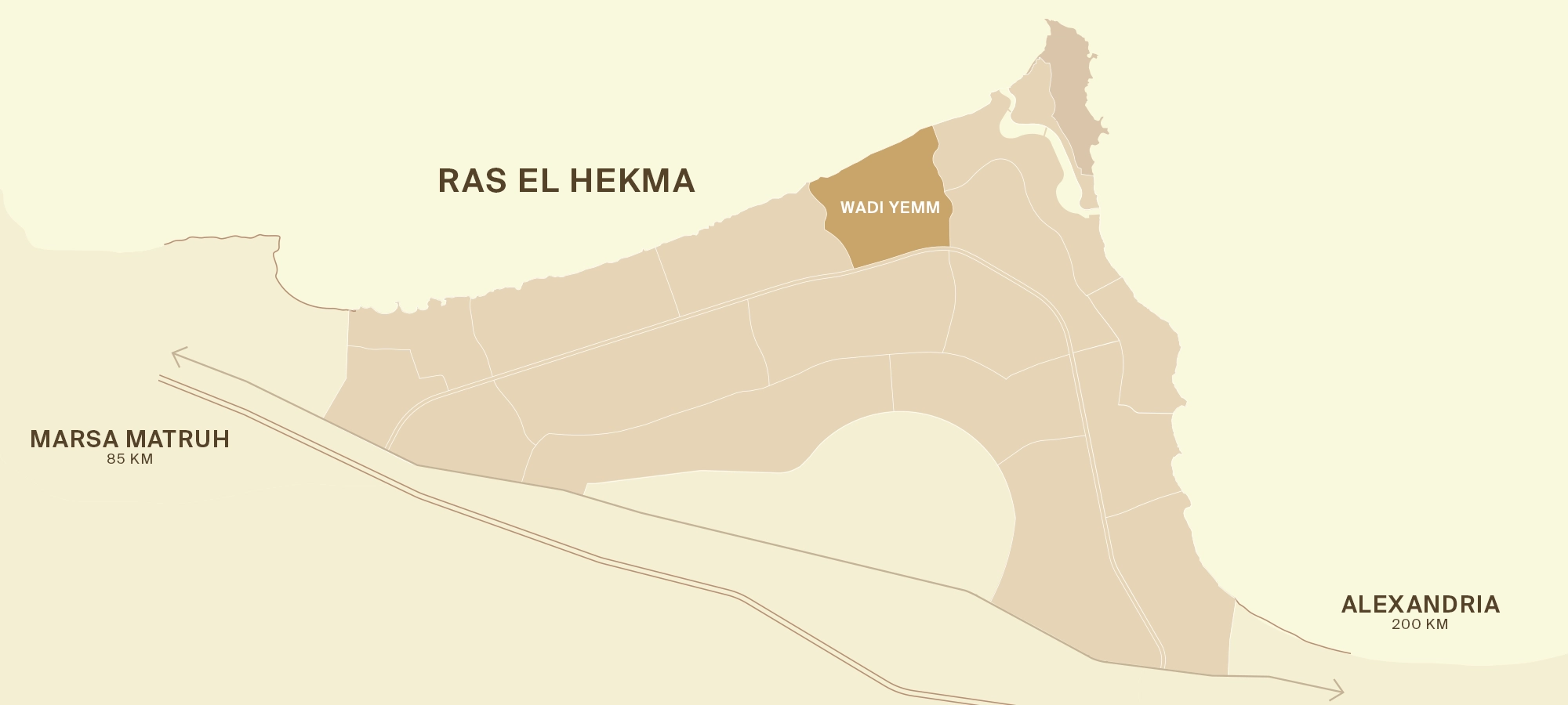
Modon’s own overview, with Wadi Yemm highlighted. Read the announced opening precinct alongside the areas still awaiting a verified individual launch in this guide.
THE FIELD ATLAS · DRAWINGS & GUIDE LAYERS
Read the detailed city drawing, trace Wadi Yemm’s shoreline and compare the Hacienda plan editions.

ANNOUNCED PRECINCT
Modon’s opening precinct. A contractor also identifies an awarded construction package; this does not establish completion across the precinct.
Read the precinct brief ↗OTHER PLANNED PRECINCTS
Individual names and launch announcements for the other 16 precincts are not verified in this guide’s reviewed primary sources. Modon’s current map leaves these areas unnamed.
“No launch verified” does not mean “definitely unannounced.” The blocks show the count, not geographic position or official precinct IDs.
Review the current city description ↗CITY PARTNER · SEPARATE STATUS
Palm Hills and Miran’s announced collaboration has an inferred city-partner relationship. The current Modon diagram does not identify Hacienda or establish which precinct contains it.
It is not added as an eighteenth precinct or assigned to an unnamed area on this map.
Read the relationship and sources ↗Reading the map: Modon uses “precincts” for these divisions. The supplied June 2026 toolkit uses “17+ precincts & free zone” on page 10, while the current public city page describes 17 precincts. Neither provides a complete named parcel register. June toolkit evidence. An earlier Modon-branded technical brochure circulated by a third party contains working district labels, but its filename says “Pending-Approval” and its labelled geography differs from the current official image. Those older labels are not promoted to current precinct names here.
City · Coast · Homes · Current official map publication date not stated · Map provenance · Earlier brochure and its limitations
13 sourced references. Projects without an accepted pin remain in the place guide. Pins do not establish city membership, boundaries, access or current operation.
Read the development context ↗The cape gives Ras El Hekma its geographic anchor. The city masterplan and the wider property address are different layers of the same story.
A CITY WITHIN A BIGGER COAST
Select a name to trace its relationship. Lines show published associations, not roads, proximity or land ownership.
THE MODON CITY FRAMEWORK
SEPARATELY MARKETED COASTAL COMMUNITIES
No city-membership line is established for these communities by the reviewed sources.
THE ANNOUNCED DEVELOPMENT STRUCTURE · OCT 2024
The appointment announcement described 170 million m², split between Modon’s first phase and development partners. This chart shows that announced allocation, not a current land survey.
Read the original announcement ↗Modon’s first phase
Development partners
Proportional area allocation · not geographic position · not Wadi Yemm’s area
THE ORIGINAL DRAWINGS
Explore the developers’ own plans at full size. Plans describe intended development; they are kept separate from satellite geography.
Miran Hills; plan branded OBMI · Labelled concept plan
The Coastal Jewel, brochure page 77. Explore the proposed neighbourhoods, lagoons and amenities; OBMI credit is retained.
Original publisher ↗Modon · City concept · report page
The citywide concept in Modon’s 2024 Responsible Business Report, page 30. This is not a labelled Wadi Yemm precinct plan.
Original publisher ↗SODIC · Oblique masterplan rendering
SODIC’s aerial concept view connects the beachfront and inland residential clusters. A rendering of intended development.
Original publisher ↗People & Places · Overhead masterplan
People & Places’ published coastal layout, with lagoons and neighbourhoods leading towards the shoreline.
Original publisher ↗Modon · Official city schematic
The current city overview published by Modon. Wadi Yemm is the only named area in this drawing; remaining precinct launch details are not verified here.
Original publisher ↗Modon · Supplied developer plan · intended development
The June toolkit’s page 22: a precinct overview with published scale figures. Keep this intended development separate from geographic boundaries.
Original publisher ↗Modon · Supplied developer plan · intended development
June toolkit page 23: 15 proposed component categories, including repeated hotel and branded-residence markers. These are not 15 city precincts.
Original publisher ↗Modon · Supplied developer plan · intended development
Generic masterplan page extracted from a supplied sales brochure. Includes Yemm Views, Fairways and Links Villas; no private offer page is reproduced.
Original publisher ↗Palm Hills × Miran Hills · Supplied developer plan · intended development
Filename dated 29 July 2026. No legend explains the arrows or faded areas, and no release phase is inferred. Separate from the labelled concept brochure.
Original publisher ↗Original plan imagery is not a registered geographic overlay. No drawing has been stretched across the satellite map or treated as a surveyed ownership boundary. Mapping method ↗
ANNOUNCEMENT IS ONE MOMENT IN THE STORY
A dated reading of the evidence. Select a milestone to see what it establishes—and what it does not.
MASTER DEVELOPER APPOINTMENT
Modon’s appointment establishes its role across the masterplan, including its first phase and a wider partnership development structure.
Completed homes, an operating airport or a surveyed parcel for a particular property.
These are separate evidence states. The timeline does not assume a project has moved through them.
THE PLACE REFERENCES
Start with the headland. This pin identifies the geographic cape, also recorded as Ras al Kanayis. The wider Ras El Hekma name is used for the surrounding coast and the announced city project.
Use your accommodation’s exact entrance for arrival. This is a geographic reference, not a gate or a public beach.
Geographic source ↗31.24704° N · 27.85414° E · Geographic referenceThe development and the nearby Fouka settlement are different map references. Use the project name when arranging arrival.
Published project reference only. Read the place brief for its city relationship, phase questions and source limits.
Geographic source ↗31.09003° N · 27.94023° E · Developer-published referenceA separate SODIC community on the coast; its name and map reference should travel with your accommodation details.
Published project reference only. Read the place brief for its city relationship, phase questions and source limits.
Geographic source ↗31.08868° N · 28.01162° E · Developer-published referenceA distinct SODIC community. It is neither an Ogami phase nor another name for Caesar.
Published project reference only. Read the place brief for its city relationship, phase questions and source limits.
Geographic source ↗31.06769° N · 28.09005° E · Developer-published referenceSODIC’s coastal community includes the Nobu hotel, restaurant and residences identity. Keep the residential phase and hospitality opening separate.
Published project reference only. Read the place brief for its city relationship, phase questions and source limits.
Geographic source ↗31.08412° N · 27.98863° E · Developer-published referencePalm Hills and Miran identify the collaboration. Miran’s development-rights announcement links it to the city project company. The exact parcel remains unverified.
Published project reference only. Read the place brief for its city relationship, phase questions and source limits.
Geographic source ↗31.17263° N · 27.68498° E · Developer-published referenceA village reference south of the headland, mapped as Fukah / Fouka. It helps distinguish the inland settlement from resort addresses along the coast.
The village pin is not a motorway exit, transport stop or confirmed collection point.
Geographic source ↗31.07331° N · 27.91778° E · Mapped settlementA separately named resort on the coast east of the cape. A resort using “Ras El Hekma” in its name should not be treated as the entire place or as proof it belongs to Modon’s project.
The marker is inside a mapped resort feature. Confirm the current guest entrance and access arrangements with your host.
Geographic source ↗31.08466° N · 28.02849° E · Mapped resort referenceA town to the east, labelled Al-Dabaah in OpenStreetMap. It is regional orientation, not a promise of a particular shop, clinic or transfer service.
For an errand, get the business’s own location and confirm opening before setting out.
Geographic source ↗31.02894° N · 28.44438° E · Mapped townA separate coastal destination west of Ras El Hekma. JAZ publishes accommodation here. This destination marker does not identify an individual hotel entrance.
Check the exact hotel, dates and guest access directly with the operator.
Geographic source ↗31.19381° N · 27.56046° E · Neighbouring destinationEmaar’s Marassi at Sidi Abdel Rahman, east of Ras El Hekma. This is the Mediterranean development; Marassi Red Sea is a different project.
Confirm a named venue and entry permission. A destination pin does not grant resort or beach access.
Geographic source ↗30.97032° N · 28.75238° E · Neighbouring developmentA city reference to the east. This point is the mapped El Alamein city label, not the boundary of New Alamein or a pin for its airport.
Use the full destination name when comparing journeys; city, airport and resort addresses are different endpoints.
Geographic source ↗30.83394° N · 28.94927° E · Mapped city referenceThe coastal city west of Ras El Hekma, also spelled Marsa Matrouh. Use it to orient yourself on the wider Mediterranean coast.
The city pin is not an airport, station or hospital. Check the specific endpoint for your journey.
Geographic source ↗31.35286° N · 27.23953° E · Mapped city referenceMap reference data © OpenStreetMap contributors (ODbL) and GeoNames (CC BY 4.0). Method & limitations.

THE GEOGRAPHIC LANDSCAPE
Explore the historical land-height map and move a section across the cape. Keep this broad landscape model separate from present ground levels and exact-home views.
Explore terrain and height sections ↗NEW / THE COASTAL LOCATOR
Explore a detailed original geographic map, compare 13 accepted reference points and keep all 21 place records in their proper city or coastal context.
Open the coastal locator ↗READ THE COMPLETE CITY PLAN
Explore nine full Modon pages, three printed marina markers and 15 city figures, with simple explanations of homes, work and daily life.
Explore the city-plan reader ↗