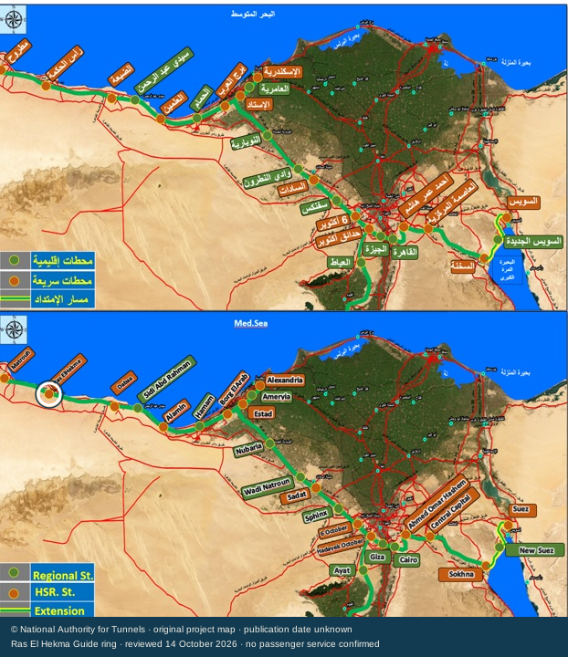
Reported station site
The report gives an area for the station site. It does not give a building footprint or plot boundary.
RAIL / THE STATION, THE NETWORK, THE LAST PART OF YOUR TRIP
The station is named in official construction reports. Here is where it appears in the published rail plan, what its earlier design report says, and what you still need to check for a real journey.
Coast section of the English panel. Ras El Hekma is the orange marker between Matrouh and Dabaa.

THE 2024 STATION REPORT
The report describes a station beside the international coastal road, facing the city. These are reported design figures, not a completed-station inspection.
The report gives an area for the station site. It does not give a building footprint or plot boundary.
Three levels are described. Their individual uses are not set out in this report.
This is a design count, not a list of platforms open to passengers.
Four tracks are described. No current route or train stopping pattern is confirmed.
A planned way to move between levels; current use is not verified.
The report also describes ordinary stairs. Their positions are not supplied.
Lifts are listed, but their installation, working condition and step-free route need a current check.
No exact entrance, pickup point, access road, internal floor plan or allocation of lifts by level is supplied in these records.
A LATER WORKS REPORT
The 24 July 2026 inspection names Ras El Hekma among nine station sites. It discusses finishing, passenger movement, elevators, tracks and access roads.
This is the report’s list of inspected stations, not a timetable or a complete list of passenger stops.
KEEP EACH DATE WITH ITS NUMBER
The August 2024 inspection gives 675 km for the first line. The July 2026 report and the project page describe about 660 km.
The guide keeps both records. It does not infer a 15 km cut, calculate a journey time from either length, or assume the whole line is open.
BEFORE YOU RELY ON RAIL
Check the operator’s current timetable for Ras El Hekma on your exact date. A construction report or trial run is not a passenger service.
Keep the station name and departure time from the ticket. Do not treat Matrouh, Alamein and Ras El Hekma as the same arrival point.
Arrange pickup at the correct station entrance and confirm entry to your community. The published rail map does not provide a Wadi or Hacienda gate transfer.
Ask about working lifts, the route to the platform, luggage and assistance. For the road transfer, confirm the vehicle, meeting point and contact before travelling.
Passenger opening, tickets, timetables and a station-to-home transfer are not verified by these source records. Use the dated coach comparison and airport atlas to research alternatives for your dates.
The complete source image is preserved without resizing or re-encoding. The guide’s ring is at image coordinate [54, 432] in its English panel; it is not a geographic coordinate. Map views change only the visible window. Buttons move or enlarge the image; scrolling over it continues to scroll this page.
Station quantities come from NAT’s 18 August 2024 inspection. The project page and map have no confirmed publication date. The later works report is dated 24 July 2026. A project plan, construction report, train trial and passenger service are different things. This reader does not confirm that trials began or that trains can be booked.
Station report ↗ · Project map ↗ · July works report ↗. © National Authority for Tunnels for the original map. Guide readings and ring are original. No authority endorsement or open republication licence is claimed.